Imagine trying to navigate a city without street addresses, traffic lights, or even street names. That's essentially how we're managing near-Earth space today. With thousands of satellites operating in overlapping orbital zones, we need a systematic way to organize, reference, and govern this three-dimensional domain. The Orbital Zoning Framework (OZF) represents my attempt to create that system—a spatial indexing approach that treats orbital space as mappable geography.
The Problem with Current Orbital Classification
Today's orbital classification system is remarkably crude. We divide space into broad categories—Low Earth Orbit (LEO), Medium Earth Orbit (MEO), Geostationary Orbit (GEO)—that span enormous volumes. LEO alone encompasses altitudes from 160 to 2,000 kilometers, representing millions of cubic kilometers of space with vastly different orbital characteristics.
This is like describing all of North America as "the continent" without acknowledging the differences between Manhattan, the Rocky Mountains, and the Gulf of Mexico. For satellite operators, regulators, and researchers, this lack of granularity creates significant challenges:
- Collision Risk Assessment: Two satellites in "LEO" could be separated by 1,500 kilometers of altitude—or they could be on intersecting orbital paths
- Regulatory Coordination: Licensing authorities struggle to assess interference potential without precise spatial references
- Mission Planning: Operators can't efficiently coordinate constellation deployments or orbital maneuvers
- Research and Analysis: Space policy researchers lack standardized spatial units for comparative analysis
Introducing Orbital Tracts
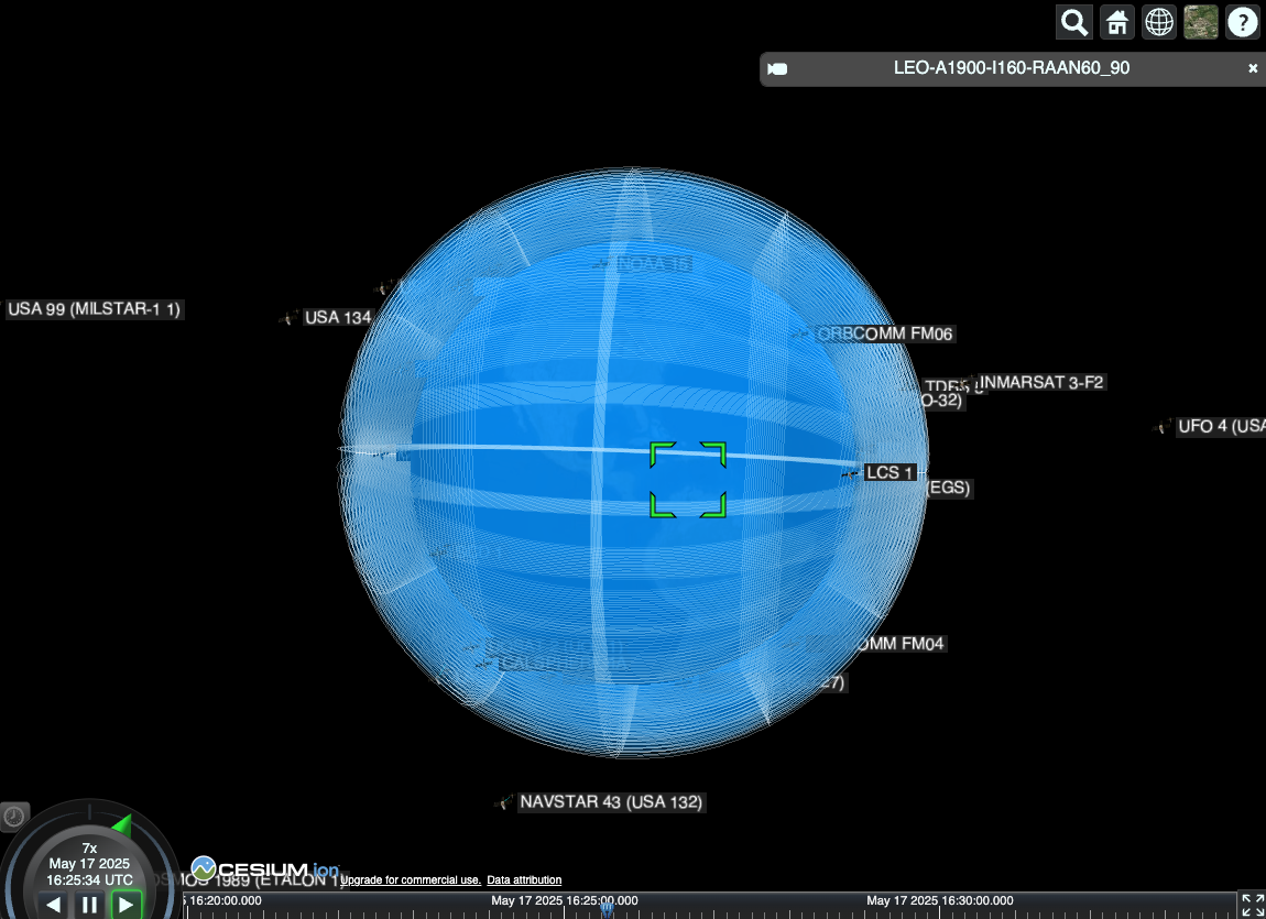
LEO-A1900-I160-RAAN60_90) shows one selected tract for reference,
with surrounding satellite markers illustrating how real spacecraft occupy this structured orbital environment.
The Orbital Zoning Framework addresses these challenges by dividing near-Earth space into discrete, three-dimensional volumes called "orbital tracts." Each tract is defined by specific ranges of orbital parameters:
- Altitude Range: Perigee and apogee boundaries that define the tract's vertical extent
- Inclination Range: The angular boundaries that define the tract's latitudinal coverage
- Right Ascension of Ascending Node (RAAN): Longitudinal boundaries that complete the three-dimensional definition
Think of it as creating a three-dimensional grid system for space, where each cell has a unique identifier and specific characteristics that can be mapped, analyzed, and governed.
Example: LEO Tract Identifier
LEO-A550-I53-RAAN0_30
Translation: Low Earth Orbit tract at 550km altitude, 53° inclination, covering right ascension from 0° to 30°
Real-world significance: This tract contains portions of the Starlink constellation's operational zone, with satellites passing through this volume approximately every 95 minutes.
The Technical Architecture
The framework operates on multiple levels of granularity, similar to how geographic information systems handle spatial data at different scales. At the highest level, we maintain the familiar LEO/MEO/GEO classifications. But within each zone, we create increasingly specific subdivisions:
Level 1: Orbital Zones
LEO: 160-2000km altitude
MEO: 2000-35,786km altitude
GEO: 35,786km altitude (geostationary belt)
HEO: >35,786km altitude (highly elliptical orbits)
Level 2: Altitude Shells
Within each zone, we define altitude shells based on operational clustering and orbital mechanics. For LEO, this might include:
LEO-A400: 350-450km (ISS operational zone)
LEO-A550: 500-600km (Starlink primary shell)
LEO-A1200: 1150-1250km (Starlink secondary shell)
Level 3: Inclination Bands
Each altitude shell is further divided by inclination, reflecting the different coverage patterns and mission requirements:
I28: 25-31° (equatorial coverage)
I53: 50-56° (mid-latitude coverage)
I70: 67-73° (high-latitude coverage)
I97: 94-100° (polar coverage)
Level 4: RAAN Sectors
Finally, we divide each inclination band by right ascension, creating discrete longitudinal sectors:
RAAN0_30: 0-30° right ascension
RAAN30_60: 30-60° right ascension
RAAN60_90: 60-90° right ascension
...and so on
Practical Applications
The power of this framework becomes apparent when we consider real-world applications. Let me walk through several scenarios where orbital tracts provide immediate value:
Constellation Management
SpaceX's Starlink constellation operates across multiple orbital tracts. Instead of describing their satellites as "in LEO," we can specify exactly which tracts they occupy:
Starlink Shell 1 Deployment
Primary Tracts: LEO-A550-I53-RAAN[0_360] (full coverage)
Satellite Count: ~1,600 satellites distributed across 12 RAAN sectors
Coordination Impact: Other operators can identify potential interference zones and plan accordingly
Collision Avoidance
Current collision avoidance relies on tracking individual objects and calculating conjunction probabilities. The tract framework adds a spatial intelligence layer that enables proactive risk management:
- Tract Density Monitoring: Real-time tracking of satellite density within each tract
- Congestion Alerts: Automated warnings when tract occupancy exceeds safe thresholds
- Routing Optimization: Mission planners can select less congested tracts for new deployments
Regulatory Framework
National space agencies and international bodies can use tracts as the basis for more granular licensing and coordination:
- Tract-Specific Licensing: Operators receive authorization for specific tracts rather than broad orbital zones
- International Coordination: ITU coordination procedures can reference specific tract identifiers
- Compliance Monitoring: Regulators can verify that satellites operate within their licensed tracts
The Visualization Challenge
One of the biggest challenges in developing this framework has been visualization. How do you display three-dimensional orbital volumes in a way that's both scientifically accurate and intuitively understandable?
The interactive visualization on my portfolio site represents one approach to this challenge. Using CesiumJS, I've created a 3D representation that shows orbital tracts as translucent volumes around Earth. Users can explore different altitude shells, see how inclination affects coverage patterns, and understand the spatial relationships between different orbital zones.
"The goal isn't just to create a new classification system—it's to make orbital space as mappable and navigable as terrestrial geography."
Data Standards and Interoperability
For the Orbital Tract Framework to achieve widespread adoption, it needs to integrate with existing space surveillance and coordination systems. This requires developing data standards that can be implemented across different platforms and organizations.
I've been working on a JSON-based data format that can represent tract definitions, occupancy data, and operational parameters in a standardized way. The format is designed to be:
- Machine-readable: Easy integration with existing satellite tracking and mission planning software
- Human-readable: Clear enough for operators and regulators to understand without specialized tools
- Extensible: Flexible enough to accommodate future orbital zones and mission types
- Interoperable: Compatible with existing orbital element formats and space surveillance data
Challenges and Limitations
The Orbital Zoning Framework isn't without challenges. Some of the key limitations I'm working to address include:
Dynamic Orbital Mechanics
Satellites don't stay in fixed positions—they're constantly moving through different tracts as they orbit. The framework needs to account for this temporal dimension while maintaining spatial clarity.
Elliptical Orbits
Highly elliptical orbits can pass through multiple altitude shells during a single orbit, complicating tract assignment and occupancy calculations.
Adoption Barriers
Any new classification system faces the challenge of overcoming existing practices and institutional inertia. The framework needs to provide clear value to encourage adoption.
Future Development
The Orbital Zoning Framework is an evolving concept. Current development priorities include:
- API Development: Creating web services that provide real-time tract occupancy and coordination data
- Machine Learning Integration: Using AI to optimize tract boundaries based on actual satellite traffic patterns
- International Standardization: Working with space agencies and industry groups to develop consensus standards
- Regulatory Pilot Programs: Partnering with national space agencies to test tract-based licensing approaches
The Bigger Picture
The Orbital Zoning Framework is ultimately about more than just organizing space—it's about creating the foundation for sustainable space development. As we transition from the early space age to an era of routine space commerce, we need governance tools that can scale with our ambitions.
Just as the development of standardized time zones, postal codes, and GPS coordinates enabled global commerce and coordination, orbital tracts could provide the spatial framework needed for the space economy. The question isn't whether we need better spatial organization for orbital space—it's whether we'll develop it proactively or be forced to create it in response to catastrophic failures.
I believe we still have the opportunity to choose the former. But that window is measured in launch cycles, not decades.
A Personal Mission
But beyond the technical specifications and policy implications, there's something more fundamental at stake here.
When I built the Orbital Zoning Framework, I wasn't just designing a new way to classify space — I was designing a way to protect it. Near-Earth space is rapidly filling with satellites, debris, and uncoordinated activity. If we don't develop clear, shared systems for orbital management, the next great conflict could start above us, not on the ground.
The future of space sustainability is inseparable from global security. The Orbital Tract Framework represents one path toward transparency — a way for nations, companies, and researchers to reference the same spatial truths. When you can map something precisely, you can manage it responsibly.
The United Nations Office for Outer Space Affairs (UNOOSA) and other international groups have already taken steps toward responsible space operations, but these efforts need a geospatial backbone. The Orbital Zoning Framework can provide that layer — a way to translate orbital activity into standardized zones and data systems that promote cooperation instead of secrecy.
Each tract functions as a digital parcel of space — a container for metadata, occupancy records, or even environmental metrics. Over time, tracts could anchor licensing data, collision alerts, or orbital debris tracking. It's not just a visualization; it's a potential language for orbital policy.
The geospatial side of this framework is still under construction. It will take community — scientists, developers, and policymakers — to bring it to full life. Space is fast. Satellites are launched every day. We need a system that can unfold in seconds, adapting to the radius of any planet or moon we explore next.
This project is my contribution to that goal — a call for open collaboration and transparency in the one domain we all share. If we can organize orbital space with precision and fairness, maybe we can also learn how to coexist in it.